Irondequoit Bay Bridge in Winter

Irondequoit Bay Bridge, Monroe County, NY

Irondequoit Bay Bridge, Monroe County, NY

Vertical Access winter projects are often trying. The days are short, and the freezing cold weather conditions mean reduced dexterity and poor battery life in our tablets and cameras – all combining to increase the difficulty of a project that might otherwise be pleasant in the spring or autumn. Even compared to most winter weather projects, the Irondequoit Bay Bridge project was extreme.

For four weeks in late February and March, we worked over the solidly-frozen Irondequoit Bay of Lake Ontario. While fishermen below peered through holes in the ice, engineers from DiDonato Associates inspected tP1150600
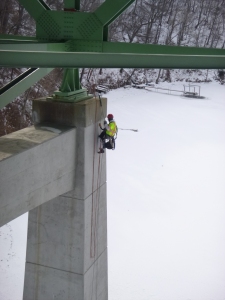
he upper areas of the bridge from under-bridge inspection units (UBIU) and we used other methods to move along thousands of feet of steel I-beams at the lower portion of the bridge. Most mornings we were greeted with sub-zero temperatures. One morning we sat in our truck, waiting for the wind chill to climb above -20°F. It never did.

Working on the Irondequoit Bay Bridge was challenging for reasons other than the record-breaking cold weather. At 2,375 feet long, we spent most of our time moving horizontally along the length of the bridge. It’s natural to use ropes as a means to move vertically. Even diagonal movement can be accomplished with efficiency using rope access. But using rope systems to move purely horizontally has its limitations. Second to the cold, our biggest challenge was planning the most efficient access system for each section of the bridge. At various locations on the bridge, we used one of three access and fall protection techniques.

Most of our time on the bridge was spent “beam scooting,”  as evidenced by the holes in the seats of our coveralls. On horizontal I-beams, we could sit comfortably on the top flange of the beam and scoot around as needed. With this access method, we used conventional fall protection methods with a shock absorbing lanyard connected to a beam clamp anchor on the beam’s flange.

To access the underside of the beams, the much more strenuous “beam rolling” technique was employed. Hanging from two or three beam clamp anchors, we would shimmy along the bottom flange of the beam. Beam rolling is tiring, because of its constant, free-hanging nature.

P1060326In the arched spans of the bridge, some of the I-beams were too steep to scoot or roll along safely. For these locations, we used the typical rope access “rope-to-rope” maneuver to traverse along the I-beams. Suspended from ropes on overhead beams, we didn’t need to balance on the underfoot beams, but rather tip-toed along them.

With our three access systems well practiced, we were able to speedily move around the bridge trusses. During the few above-freezing site days that we enjoyed, it was clear that the biggest contributor to our efficiency was warm weather. With less bulky clothing and more manual dexterity, we seemed to zip along. We hope to someday return to the Irondequoit Bay Bridge in the summer and enjoy working over an unfrozen bay.

All photos by Vertical Access.

Removal of the Clock Hands on Fordham University’s Rose Hill Campus

by Kevin Dalton

We recently worked on an interesting project at Fordham University’s Rose Hill campus in the Bronx.  Our mission: to remove the clock hands from four clock faces on the tower of Keating Hall and one clock atop LaLande Hall in Martyrs Court.

The hands were removed and turned over to The Verdin Company so they could be restored. Once restored, the hands will be re-installed. The project was coordinated by Bob Rush with Structure Tone, Inc.

The crenellated parapet at the top of the tower on Keating had bird protection on the top of the walls so we had to lower ropes through the crenels and climb up to the clock which was about a 150’ climb from the roof of the main building below.

The clock hands were pretty big; the hour hand was a little over 6’ long and the minute hand was over 7’ long. We rigged all the hands to lower before loosening any of the nuts or bolts that connected them to the shaft.

One of the minute hands was stuck and we had a really hard time removing it. It typically took us 30-45 minutes to remove both hands on each of three out of four faces but we spent over 3 hours on the southeast face on the first day trying to remove the minute hand without success. It was a little over 20 degrees (Fahrenheit) and the wind was blowing 15 – 20 mph directly into my face so I decided to accept defeat and go get warm before moving onto another set of hands. We came back to the southeast face the next day with a specialty tool provided by Dennis Lindo from The Verdin Company and after a few minutes the hand was free.

We finished up the second day at Martyrs Court which was only about 50’ off the ground but in an area that is difficult to access with a lift. Due to icy conditions on the roof we thought it safer to toss the ropes out to the face of the building and climb up from the ground. After almost 1,000’ of vertical climbing at Keating Hall 50’ was a walk in the park.

When I arrived at the clock face I had the minute hand off in a matter of minutes but the hour hand looked like it might take hours to remove. It was completely rusted onto the shaft and wouldn’t budge. Luckily the entire mechanism is being replaced so Dennis cut the shaft from the inside with a reciprocating saw. The white part of the clock  is just a thin piece of glass (probably 1/8” thick) so we had to saw very carefully. Fortunately we were able to keep the shaft off the glass and the hand came off without incident.

Who is Buried in Grant’s Tomb? *

Grant’s Tomb is off the beaten track tread by most visitors to Manhattan. Photo credit: www.timeshutter.com

Grant’s Tomb is off the beaten track tread by most visitors to Manhattan.
Photo source: www.timeshutter.com

Once one of the most popular attractions in New York City, today Grant’s Tomb is off the beaten track tread by most visitors to Manhattan.  Constructed with the assistance of donations from 90,000 people totaling $600,000, the most money raised for a public monument at the time, the structure later suffered from neglect and fell into decline.[1]  Although it stands on a prominent point of Riverside Park overlooking the Hudson River, Grant’s Tomb is hidden in plain sight, with relatively few people venturing inside the mausoleum that contains the remains of President Ulysses S. Grant and his wife, Julia Dent Grant. 


 Grant’s Tomb was constructed between 1891 and 1897. Photo source: xxxx

Grant’s Tomb was constructed between 1891 and 1897. Photo source: National Park Service

Grant’s Tomb was designed by New York architect John H. Duncan and constructed between 1891 and 1897.  The exterior is based on the Mausoleum of Halicarnassus and the interior is modeled after the Tomb of Napoleon at Les Invalides in Paris.  On the exterior, the structure consists of a square base surmounted by a conical dome with a tall, colonnaded drum level, all faced with granite.  The main entry on the south side of the structure is distinguished by a wide plaza with steps leading up to a portico covering monumental bronze doors.  The ground floor has a large oculus through which the sarcophagi on the floor below can be seen.  Polished marble from Massachusetts is used for the interior floor surfaces and the railings, trim and dados at the walls of the ground floor and basement are clad with Italian marble.  The upper areas of the interior, including four barrel vaults facing the cardinal directions of the base of the monument, the pendentives where the square base transitions to the dome, the gallery at the drum level and the coffered ceiling at the interior dome, are faced with ornamental cast plaster.

The Grant Monument Association operated Grant’s Tomb until 1959, at which time the National Park Service took over management control and the site was designated as General Grant National Memorial.  From the 1970s to the early 1990s, visitors who ventured to Grant’s Tomb would find the granite walls of the monument covered with graffiti, the glass in the windows broken and the site in an overall state of disrepair.  Finally, faced with public criticism and a threat from the Illinois state legislature to move the remains of the Grants to their state, the federal government undertook much-needed repairs.  Following the restoration effort, the monument was re-dedicated on April 27, 1997.

Hands-on investigation of the plaster pilasters. Photo by Vertical Access.

Hands-on investigation of the plaster pilasters. Photo by Vertical Access.

As part of a site inspection of the General Grant National Memorial performed in 2012, National Park Service staff identified areas of cracking at the interior plaster at the drum level of the rotunda.  Some of the plaster at the pilasters at this area appeared detached.  The National Park Service requested the services of Vertical Access to perform a hands-on investigation of the plaster pilasters to better understand the causes of the cracks and determine whether the current condition presented an immediate public safety hazard.

As part of the investigation of the interior plaster, Vertical Access utilized several non-destructive and diagnostic tools.  As a first step, VA laid out the location of rigging holes in the coffered ceiling for the industrial rope access approach.  To locate the first rigging hole at the ceiling, a self-leveling laser level positioned on the ground floor was first used to establish the plumb line for the drop ropes in front of one of the pilasters.  To confirm which coffer was in line with the center of the pilaster when viewed from the attic side of the ceiling, the unfinished attic side of the coffer was warmed with a heat gun and the finished interior side was viewed with an infrared camera from the ground level.

 Conditions were documented using annotated drawings, still photography and video. Photo by Vertical Access.

Conditions were documented using annotated drawings, still photography and video. Photo by Vertical Access.

Once drop ropes were in place, Vertical Access technicians performed the hands-on investigation of the plaster pilasters, using diagnostic tools to better understand the construction of the pilasters and further investigate conditions of deterioration observed at the face of the pilasters.  A wall tie locator and rigid tube borescopes with a 0° (straight ahead) and 90° (right angle) direction of view as well as a 36”-long flexible tube borescope were employed during the investigation.  A video camera attached to the borescope unit provided recorded documentation of the subsurface conditions.  The cast plaster sections of the pilasters appear to be attached to the brick back-up structure with wood blocking.  Metal elements including wire ties and nails appear to have been used but no evidence of straps or anchors into the plaster was found.

 Conditions identified during the hands-on and close visual examination of the interior plaster were documented using annotated drawings, still photography and video.  At the conclusion of the investigation, Vertical Access installed crack monitors at two different pilasters.  Although the condition of the interior plaster does not represent an immediate threat to public safety, the crack monitors will be used to help determine whether the cracks observed are active.


* From Groucho Marx in the game show “You Bet Your Life”.  The correct answer is no one, since Ulysses S. Grant and his wife Julia are entombed but not buried in the memorial.

[1] Keister, Douglas.  Stories in Stone New York: A Field Guide to New York City Area Cemeteries & their Residents: Layton, UT: Gibbs Smith, 2011.  Page 142.

Flume Fever – The Video

Catching Flume Fever
by Mara Ferris of Gen 9 Productions

Never realizing its rich history, I have stopped many times along the Unaweep-Tabeguache Scenic byway to view the remnants of the spectacular wooden structure hanging high on the red rock walls above the San Miguel and Dolores Rivers. As a filmmaker based in Western Colorado I had photographed the structure several times and always pondered the story behind this vibrant piece of living history.  Thankfully my team was hired to film the Hanging Flume reconstruction project in April 2012 and our knowledge of the rich and colorful history quickly grew. We caught ‘Flume Fever’ as soon as filming began!

Contracted by Western Colorado Interpretive Association to film the reconstruction and produce a short video we had the pleasure of spending four days shooting footage, gathering interviews and learning the story of the structure.  This short documentary will be used as an educational tool to help inspire future historical preservation projects along the scenic byway and promote the preservation of our local history for future generations. It was a thrill to see the Vertical Access team work, and I am grateful we were all able to share in the ‘Flume Fever‘ – enjoy the trailer to the film here!

[vimeo http://www.vimeo.com/51223922 w=440&h=247]

Watch the full-screen version of the Flume Fever trailer here

Engineering Marvel Unaweep Canyon Hanging Flume to be Reconstructed

Hanging Flume in 1891 shortly after it was completed. The flume was 4 feet deep and 6 feet wide.

The hanging flume, of which 7 of its 13 miles clings to a red-rock wall along the San Miguel River in the San Miguel and Dolores Rivers canyons, might leave viewers wondering why and when this wooden structure was built.

…However, except for the brief explanation in the “History of the State of Colorado” by Frank Hall, it has remained a mystery how the flume was constructed on the sheer, rock walls.

Several scientists have worked since 2004 to unravel the mystery. They have had no photographs, engineering drawings or written accounts chronicling the flume’s construction. However, it is possible that Ron Anthony of Anthony & Associates, a wood scientist from Fort Collins, and Robert Silman Associates P.C. have discovered the answer.

From April 10–15, Anthony & Associates, Vertical Access and Robert Silman Associates P.C. will put their theories to the test by attempting an onsite reconstruction of 48 feet of flume, using what they believe are the original methods of construction.

The public can watch the possible unraveling of this historic structure from several viewing locations along Colorado Highway 141 on any of the six days.  READ FULL ARTICLE  Engineering marvel Unaweep Canyon Hanging Flume to be reconstructed | GJSentinel.com.

120-year-old mystery to be solved next week

Courtesy photo

Hanging Flume reconstruction begins Wednesday
By Ellen Metrick, Editor
Published: Tuesday, April 3, 2012 11:29 PM CDT

Workers on reconnaissance, rappelling from Hwy. 141, above the San Miguel River, to mark the 48 feet of the Hanging Flume to be reconstructed in a grand event next week. “You might call it historic reenactment, except that no one is completely certain the construction methods that will be employed to restore 48 feet of the Hanging Flume are historically accurate. Nonetheless, the feats that workers will undertake on a short stretch of the crumbling 10-mile long hydraulic wonder, built in 1889 above the San Miguel and Dolores rivers, promise to be stunning and hope to be successful.

“This is very exciting,” said Chris Miller, the executive director of the Western Colorado Interpretive Association (WCIA). “It’s the culmination of 10 years of research.”

Neon green tags marking the stretch of flume to be restored are already visible on the canyon wall above the San Miguel River, just upstream from its confluence with the Dolores. Workers rappelled down the cliffs from Hwy. 141 to place them one month ago, preparing for next week’s event.”  READ FULL ARTICLE > Telluride Daily Planet > Norwood Post > News

Eight Years Later: A Return To The Hanging Flume

Vertical Access technician Donn Hewes surveying remaining elements of the Hanging Flume near historic Uravan, Colorado.

Driving along the San Miguel River near the historic town of Uravan in western Colorado, one has to study the cliffs to find remnants of a 10 mile long structure built 120 years ago.  Constructed by the Montrose Placer Mining Company between 1889 and 1891, the Hanging Flume ended its service life in 1903 and has since succumbed to weathering, rock fall and plundering by locals in need of timber.

With much of the structure long gone and few existing original documents and photographs, myriad mysteries surround the construction process.  Did the workers use a steam engine powered drill, or were the thousands of anchor holes in the sandstone drilled with only a hammer and chisel?  How were the frames weighing more than 300 pounds moved into place?  These and other questions have stirred up a “flume fever” in residents of neighboring communities.  It is known that at its completion, the Flume was a 10-mile long series of wooden and earthen troughs carrying 80 million gallons of water per day to gold mines.

In 2004, Vertical Access teamed with Robert Silman Associates, Anthony & Associates and Western Colorado Interpretive Association (et al.) to document representative sections of the Flume.  Eight years later, VA technicians returned to the Flume to begin a new phase of work.

A 1/8 scale model of the Hanging Flume, built by Vertical Access.

Keith Luscinski and Donn Hewes were on site February 10-12 to gather more information on one particular “hanging” section, that is, a section that was built on the side of the cliff.  Taking dimensions and recording deterioration, the two technicians gathered information to prepare for reconstruction of the 50-foot long section that is slated to take place in April.  The building process will not only help answer questions about the original construction techniques, but also provide residents and visitors of the area with a representation of the original structure.

Vertical Access will be working with other members of the project team over the next two months to acquire the necessary timbers and arrange construction logistics.  As part of the preparation process, VA has constructed a 1/8-scale model of two sections of the Hanging Flume.  The model has already proved valuable by providing insight into the assembly process.  Stay tuned for updates on the final product in April!

[youtube http://www.youtube.com/watch?v=Lu6Bnr91THM]

Vertical Access Top 10 of 2010: Project 7 – The Galleria, New York, NY

“Ladder” for descending over plexiglass panels

In June 2010, a major wind event passed through New York City and dislodged a large pane of glass from a balcony near the top of the Galleria building in midtown Manhattan, resulting in extensive damage to the glass-enclosed balconies on the south facade of the building. The Galleria, a mixed use building, has an eight-story base with commercial offices and a public atrium, and a 47-story residential tower with “winter garden” balconies above the 19th floor. At the time of its construction in 1975, the building was the tallest concrete-framed structure in New York.

Following the glazing collapse, Vertical Access was retained by Israel Berger & Associates to identify public safety concerns at the winter garden balconies and document the condition of the balconies where the glass had become dislodged as well as the other balconies. The project posed an interesting rigging challenge for Vertical Access, as access to the balconies on the south facade of the Galleria from the rooftop terrace required descending down a curved plexiglass enclosure. To avoid putting weight directly onto the plexiglass panels, founding partner Kent Diebolt and level 3 supervisor Keith Luscinski developed a “ladder” system consisting of aluminum tube spreaders, spanning across the mullions of the enclosure. This allowed VA technicians performing the investigation to safely lower themselves onto the south facade and complete the investigation of the winter garden balconies.

Keith decending down Galleria south facade

Read about Project 1: Union Theological Seminary Brown Tower
Read about Project 2: University of Buffalo Alumni Arena
Read about Project 3: United States Capitol Dome
Read about Project 4: Boston College Burns Library Tower
Read about Project 5: Mayo Clinic Gonda Building
Read about Project 6: Convent of the Sacred Heart School