Posted on by Kristen OlsonLast modified: January 27, 2020
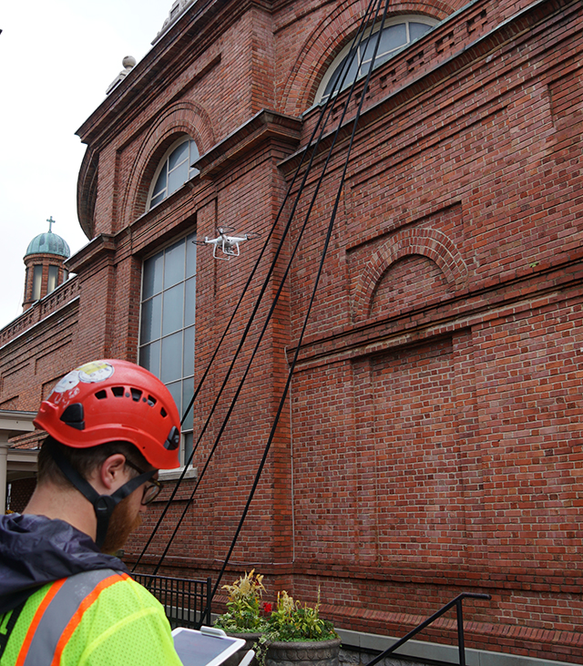
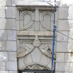
Patrick Capruso piloting a UAS as part of a conditions assessment of The Basilica of St. Lawrence in Asheville, NC
In late December, the Federal Aviation Administration announced a proposed rule for the remote identification of drones, a step considered by the agency to be critical in achieving the full integration of Unmanned Aerial Systems (UAS) into the national air space.
The proposed rule would require almost all UAS weighing more than 0.55 pounds to be able to broadcast their identity and location directly from the aircraft and/or transmit that information via internet link from takeoff to landing to an FAA-approved third party service provider, allowing law enforcement agencies and the public access to real-time information about where drones are flying. Manufacturers would have up to two years to make sure their products meet the performance requirements, and operators would have up to three years from the rule’s effective date to comply. It’s estimated that most unmanned aircraft currently available to consumers could be made compliant via software updates.
According to the FAA, remote identification is a step towards enabling the safe authorization of flights over people and moving vehicles as well as flights beyond visual line of sight, both of which are necessary for full-scale implementation of drone deliveries, emergency response support, and infrastructure inspection.
The public comment period for the proposed rule is open through March 2, 2020.
Posted on by Kristen OlsonLast modified: January 29, 2020
Published in November 2019 by CRC Press, Applications of Small Unmanned Aircraft Systems: Best Practices and Case Studies presents case studies for UAS-enabled applications across a range of disciplines. Drones have made established technologies like photogrammetry, aerial imaging, and mapping affordable and accessible. Now, early adopters are sharing their expertise, allowing researchers, governments, and businesses to fully understand what is possible and to envision new UAS applications.
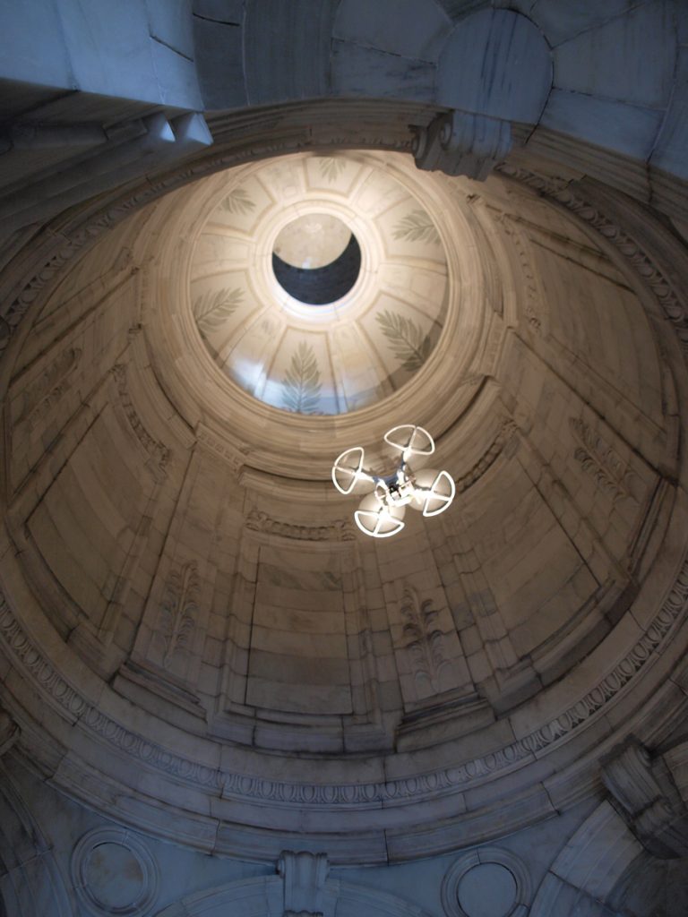
Kristen Olson wrote about Vertical Access’s work at the Soldiers’ and Sailors’ Memorial Monument in her contribution to chapter 9, “Small Unmanned Aerial Systems (sUAS) and Structure from Motion for Identifying, Documenting, and Monitoring Cultural and Natural Resources”. VA used multiple means of access to gather information about the exterior and interior of the monument, including UAS to document existing conditions at inaccessible interior spaces. Kristen co-presented on this case study at the National Center for Preservation Training and Technology Digital Documentation Summit in New Orleans in 2017 along with Douglas Gonzalez of Leslie E. Robertson Associates.
Posted on by Kristen OlsonLast modified: October 5, 2018
The biggest obstacle to utilizing UAVs for building documentation has been the prohibition on flying within restricted airspace surrounding airports. Since 2016, authorization to operate in this airspace has depended on case-by-case review by the Federal Aviation Administration with a typical lead time of at least 90 days. By 2018, the backlog for reviewing airspace authorization requests had grown to 6 months or longer.
Shown here is Kristen Olson surveying Springfield, MA’s Campanile clock tower with a drone for Bruner/Cott Architects. We are assisting with a wide range of discovery phase tasks as part of the Springfield Campanile Restoration and the drone is one tool helping us provide a complete picture.
Beginning earlier this year, the FAA made available a new system for requesting authorization to operate UAVs within restricted airspace, called LAANC, or Low Altitude Authorization and Notification Capability. LAANC is a partnership between the FAA and third-party providers such as AirMap and Skyward, who have developed app-based platforms to allow UAV pilots to apply for and obtain airspace authorization in near-real time. LAANC was rolled out over a period of six months, and as of September 13, all of the regions in the US are on-line, although not all airports are participating as of this time.
The LAANC concept is based on maps showing predetermined maximum flight altitudes in a grid pattern surrounding an airport. While flights very close to airports are still off-limits (or will require a more rigorous application and vetting process), the LAANC system greatly expands the possibilities for UAVs to gather valuable information about buildings and structures in U.S. cities. To put it in perspective, more than half of the downtown areas of Albany, Boston, Baton Rouge, Phoenix, Salt Lake City, and Kansas City (to name just a few) were effectively off-limits to commercial UAV flight prior to LAANC.
The next development, still years away, will be a system developed by the FAA and NASA to fully integrate low-altitude flight into the national airspace.
Posted on by Kristen OlsonLast modified: October 2, 2018
Photogrammetry is the practice of extrapolating spatial relationships from photographic imagery. While the concept of photogrammetry is centuries old, today’s powerful software quickly generates a 3-dimensional point cloud of any scene or object captured with a half dozen or up to several hundred overlapping digital photographs. Two recent projects illustrate very different applications for this technology in expanding what Vertical Access can do for clients in hard to reach areas.
Using Unmanned Aerial Vehicles for Conditions Documentation and Image Capture
Work on existing structures begins with accurate as-built documentation. But what if there is no background drawing on file for use in the field?
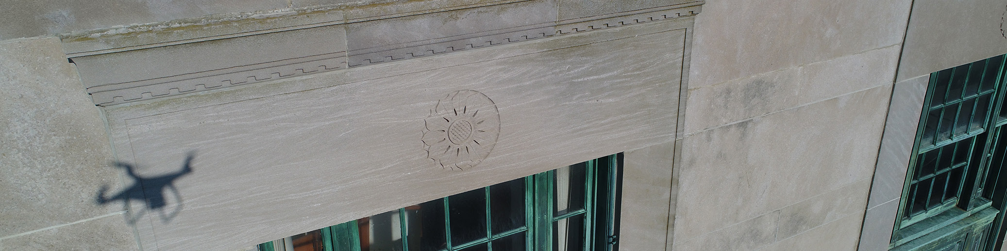
Enter photogrammetry. On a recent project, the main façade of a building could not be surveyed with an aerial lift due to site features, leading the project team to investigate the use of an unmanned aerial vehicle (drone) to capture close-range imagery of the façade conditions as well as photographs for use in the creation of scaled, detailed background drawings.
Vertical Access’ licensed drone pilots operated a DJI Phantom 2 drone to obtain medium-range imagery for the creation of a photogrammetric 3D point cloud, as well as close-range 4K video for the conditions documentation of the structure. The field work was accomplished by a team of two pilots in less than two days and required only partial closure of the pedestrian walkway to safely conduct the drone flights.
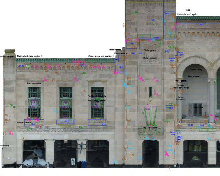
2D elevations generated from the 3D model annotated with fault conditions in AutoCAD. Fault conditions such as cracks, spalls, and displaced masonry units were annotated digitally using the Tablet PC Annotation System (TPAS®).
Back in the office, VA used Pix4D Mapper Pro photogrammetry software to generate the point cloud, textured mesh, and 2D orthoimages of the main façade, side wings, and tower returns. The orthoimages were scaled and placed as background images in an AutoCAD drawing, and fault conditions such as cracks, spalls, and displaced masonry units were annotated digitally using the Tablet PC Annotation System (TPAS®). Condition quantities were extracted from the AutoCAD drawing into an Excel spreadsheet to facilitate repair cost estimates.
A close-range visual inspection as well as image capture for photogrammetry were completed in much less time than it would have taken to inspect the façades and obtain hand measurements using an aerial lift. The field work was accomplished with minimal disruption to pedestrians.
Deliverables from this study include a scaled 3D point cloud and textured mesh, 3D PDF model, background drawings based on orthoimages generated from the photogrammetric point cloud, and 4K video documenting façade conditions at close range, with over 800 video stills hyperlinked to conditions annotations in the AutoCAD elevation drawings.
Modeling Decorative Features of Historic Structures With Photogrammetry
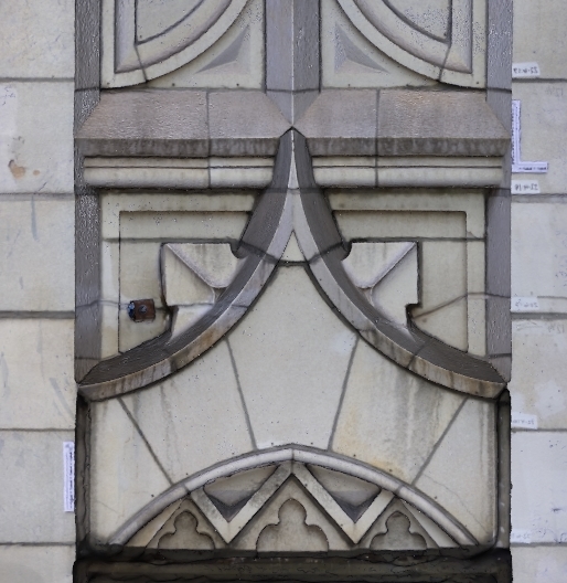
A 3D3D photogrammetric models of an individual terra cotta unit, to be transformed into shop drawings for replacement units.
Restoration of historic decorative terra cotta, cast stone, or natural stone often requires extensive replacement of individual units. Erecting scaffolding for hands-on access to measure and remove existing units adds significant cost to project budgets.
Vertical Access recently used photogrammetry to aid in a pilot project as an alternative option for acquiring dimensions of existing units.
Vertical Access photographed a terra cotta spandrel panel and parapet, using existing scaffolding to gain hands-on and close-range access. The photographs were used to create 3D photogrammetric models of individual units, to be transformed into shop drawings for replacement units.
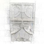
Step 2 The densified point cloud
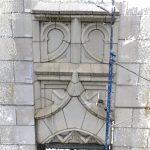
Step 3 Creation of the 3D mesh
With VA’s demonstrated rope access capability, units can be photographed and modeled without the need for scaffolding, yielding a cost savings for the building owner.
At Vertical Access, we go to great lengths—and heights—to help you gather meaningful data about your project’s site conditions. Our Unmanned Aerial Vehicle (UAV) services bring together the expertise of five FAA-certified drone pilots, architectural conservators, engineers and historians to investigate buildings and infrastructure.
Vertical Access enhances our inspections services at any height with a team of FAA-certified UAV pilots. Our pilots utilize drone technology in a number of applications ranging from reconnaissance surveys highlighting areas of concern for further investigation to flying lightweight rigging cords up-and-over structural elements to gain hands-on access.
We currently operate a fleet of DJI™ Phantom quadcopter Unmanned Aerial Vehicles (UAVs or drones) to aid in the investigation of buildings and infrastructure. If hands-on access is not feasible, high resolution photographs and video taken from mounted cameras provide sharp images for conditions assessment.
Regardless of the application, our team operates in full compliance with FAA Part 107, Small Unmanned Aircraft Regulations. All of our aircraft are registered and each of our TSA-vetted operators holds a Remote Pilot Certificate.
More information on our UAV Surveys is found here and in published articles including: Olson, Kristen, and Kelly Streeter, P.E. “3D Models Take Off with Drone Technology.” SWRI Applicator Magazine, Summer 2016. Download the UAV Technical Highlight here.
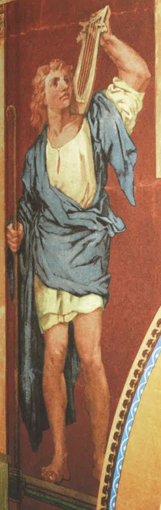
Vertical Access has had the privilege of making several trips to Boston’s Trinity Church over the years in order to assist with the investigation of interior and exterior conditions. Consecrated in 1877 and situated on a prominent public square in Boston’s Back Bay, Trinity Church is considered the masterpiece of architect Henry Hobson Richardson. Today, the parish is officially known as Trinity Church in the City of Boston.
Trinity Church, a National Historic Landmark, is one of the finest examples of American architecture of the late nineteenth century. H.H. Richardson’s competition-winning design employs the rounded arches, deep window reveals and turret forms that are characteristic of his eponymous style, Richardsonian Romanesque. Trinity is organized as a compact Greek cross, with an auditorium-like seating arrangement beneath a massive, square central tower. The church is decorated with richly-colored interior murals by John La Farge, sculpture by Daniel Chester French and Augustus Saint-Gaudens, and stained glass windows by La Farge and other leading glass designers.
A five-year restoration of the church and parish house began in 2001, directed by Goody Clancy. Work included masonry repairs at the tower exterior, improvements to life safety and mechanical systems, and restoration of the stained glass windows and interior finishes. Also as part of the project, the church undercroft and parish house basement underwent an award-winning conversion into universally-accessible meeting and classroom spaces.
As exterior work began in the spring of 2003, Vertical Access was asked to document the La Farge murals and architectural details at the interior of the central church tower. Industrial rope access was used to gain access to the tower interior, and VA scheduled the work to avoid interrupting the three daily church services. Vertical Access worked closely with Goody Clancy to capture high-quality imagery of the delicate interior finishes.
Looking down from the attic, a Boston Globe photographer captured James Banta, left, and Kent Diebolt, with camera, documenting the La Farge murals inside Trinity Church’s central tower.
Vertical Access’ photodocumentation was used by the Trinity Boston Preservation Trust in their 2004 campaign to fund the restoration of Trinity’s murals and stained glass windows.
David, photographed by Vertical Access in 2003.
More than a decade after the interior documentation and restoration, VA returned to Trinity in August, 2016. Kelly Streeter and Kristen Olson joined Casey Williams of Simpson, Gumpertz & Heger on the tower roof to document the condition of the clay tile roof, along with the northeast turret. VA was working for SGH, who were under the direction of Goody Clancy.
From left, Casey Williams, Kelly Streeter, and Kristen Olson on the central tower in 2016, with the “world’s longest selfie-stick”. The pole-mounted GoPro camera was used to document the condition of the copper cross and stanchion atop the tower.
VA’s latest visit took place in September, when Kelly and Kristen participated in the Documentation Technologies Workshop presented by the Northeast Chapter of the Association for Preservation Technology. The event brought together an international audience for presentations and demonstrations of cutting-edge technology used in the documentation and characterization of historic structures.
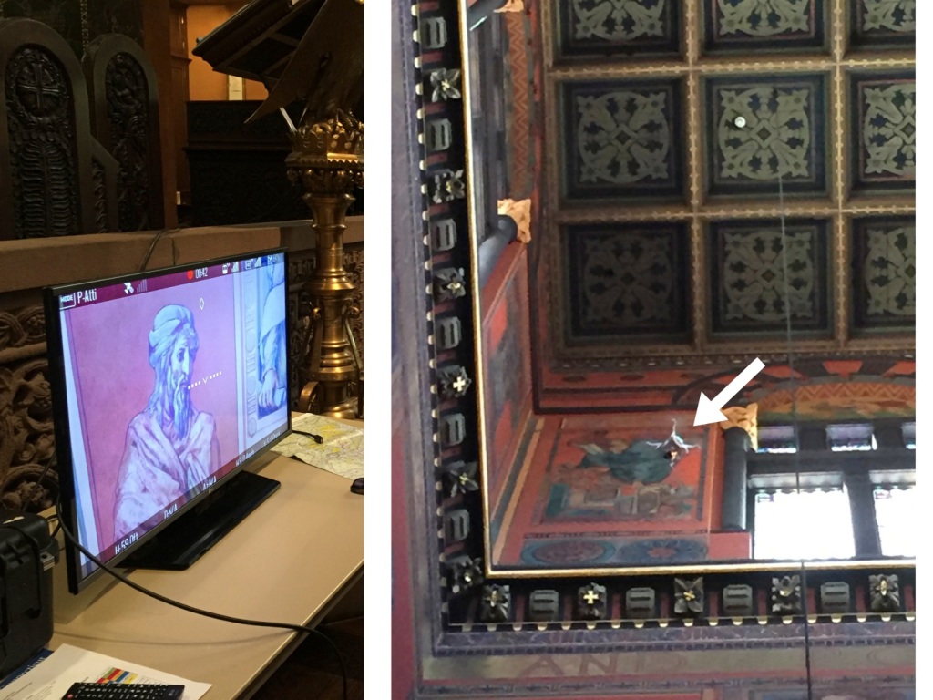
Kelly and Kristen presented “Drones: The Good, the Bad, and the Unknown”, an overview of the applications for drones in building documentation, the potential for drones to augment hands-on inspections, available drone hardware and accessory technologies, and current FAA regulations. We followed the presentation with a live demonstration of our new drone, a DJI Phantom 4, inside the church sanctuary.
Left, a live feed video stream of the interior murals as they are captured by the drone, at right.
WASHINGTON – Today, the Department of Transportation’s Federal Aviation Administration has finalized the first operational rules (PDF) for routine commercial use of small unmanned aircraft systems (UAS or “drones”), opening pathways towards fully integrating UAS into the nation’s airspace. These new regulations work to harness new innovations safely, to spur job growth, advance critical scientific research and save lives.
Dozens of software options are available for stitching photographs into scaleable, 2D mosaics or 3D models. We’ve been experimenting with a few different platforms for generating 3D models using footage captured by our DJI Phantom UAV (drone) or by technicians on the ground.
In the example below, the photogrammetry software could not accurately render the metal roof of our shed because the photos used to create the model were taken by a person on the ground. Achieving a higher angle of view, for example, by using a UAV, the software would have created a more complete model. This 3D model was built using only 51 images.
3D model created using photogrammetry
Some programs can output a 2D elevation or plan extracted from the 3D model, which can be used to create scale drawings with centimeter accuracy.
orthorectified 2D image generated from a 3D model
These outputs can be used as background drawings for a hands-on survey using TPAS, or to take measurements of inaccessible features such as antennas or finials.
This fly-through of a barn is of a 3D model created where the green line represents the flight path of the UAV and the dots represent the locations of where photographs were taken. Enjoy the drone’s-eye view: